Severe weather possible across Alabama: Hereâs what it looks like where you live
Today could be a busy day for severe weather across Alabama.
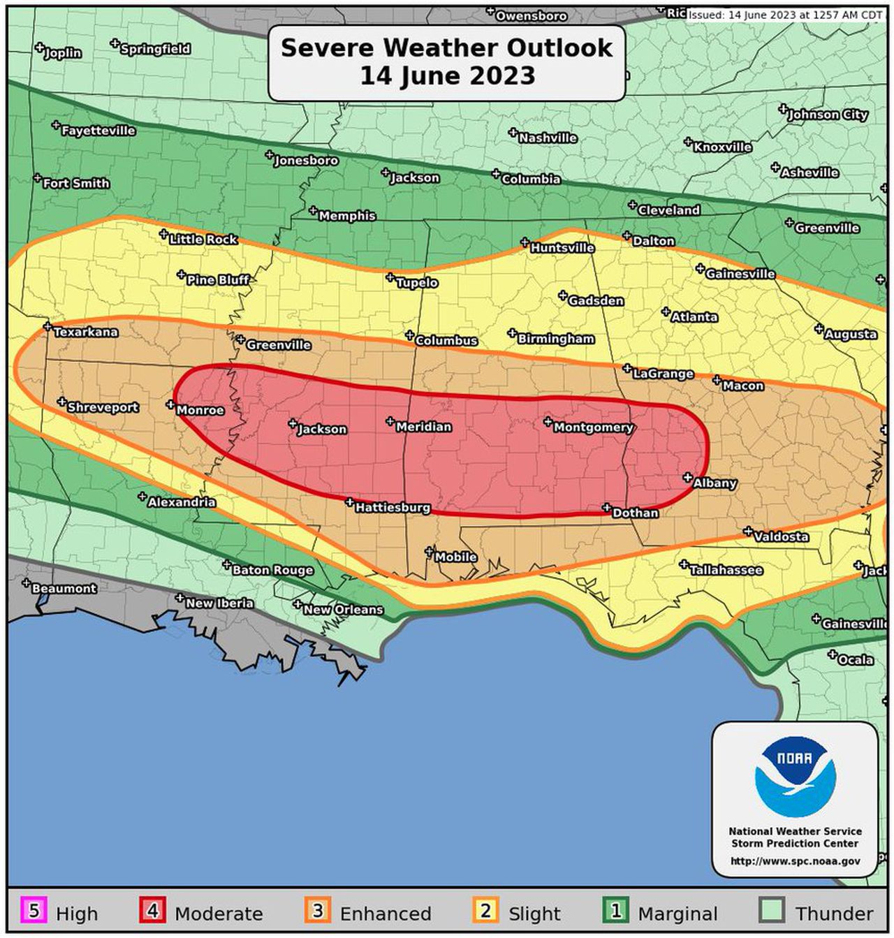
The entire state is under some sort of severe weather risk from the Storm Prediction Center, but there is a Level 4 out of 5 risk in place today for parts of south-central and south Alabama.
A Level 4 risk means numerous, intense storms will be likely.
The strongest could have wind gusts as high as 80 mph (that’s hurricane force), hail up to the size of baseballs, lots of lightning and flooding rain.
A flood watch is in effect for the southern part of the state.
Storms will be possible in multiple waves today, and more storms will be possible, mainly in south Alabama, on Thursday.
Friday will bring yet another risk for severe storms, this time for nearly all of Alabama.
That’s a lot of weather. Here’s what the National Weather Service is expecting for your region of the state.
NORTH ALABAMA
Main points:
* Multiple rounds of storms are possible throughout the day, but the strongest thunderstorms are expected this afternoon into tonight.
* Large hail (up to 2 inches, or the size of a lime) will be the main threat, but damaging winds can also occur.
The National Weather Service in Huntsville said storms will be possible across the Tennessee Valley today, but the best chances for severe storms will be generally south of the Tennessee River.
Storms will be possible through around 9 p.m., forecasters said. They could get going as individual cells over the area or just to our west and morph into more of a line with widespread stronger winds.
CENTRAL ALABAMA
Main points:
* Multiple waves of thunderstorms are expected this morning through Thursday night. Severe thunderstorms are likely, and these have the potential to bring large hail, damaging winds and a tornado as well as flash flooding.
* A Level 4 or moderate risk is in the forecast today for areas roughly from Clanton southward. A west-east swath from Tuscaloosa to Clanton to Alexander City has an enhanced (Level 3) risk. The Birmingham metro area roughly northward to Hamilton and Gadsden has a slight (Level 2) risk.
* A flood watch is in effect for the southern part of the region.
* Additional waves of thunderstorms are possible later this week.
As for timing: Storms moved through this morning, and more waves of storms will be possible starting the afternoon and could last into tonight.
The National Weather Service in Birmingham said hail up to baseball size (2.75 inches) will be possible with today’s storms, mainly in the moderate risk area to the south of Birmingham. Winds up to 80 mph and flash flooding will also be possible.
Forecasters said a tornado “cannot be ruled out” in the southern part of the region.
Thursday’s storms are expected to mainly affect the southern part of central Alabama and will be possible Thursday afternoon and Thursday night. Large hail and wind gusts to 60 mph will be possible Thursday.
Friday’s storms are also expected across the southern part of the region and could have large hail and gusts up to 60 mph. The timeframe will again be Friday afternoon into Friday night.
SOUTH ALABAMA
Main points:
* Three rounds of severe weather and flash flooding are expected today through Thursday. There is a moderate risk for severe storms today and a slight risk for Thursday.
* There will be the potential for “significant” straight line winds up to 80 mph, tornadoes — a few of which may be strong — and very large hail up to egg size.
* There is slight risk for flash flooding for interior southwest and south-central Alabama, and a flood watch is in effect.
The National Weather Service in Mobile has outlined timing for today’s weather for its region in southwest and south Alabama:
Timing Round 1: 9 a.m. – 2 p.m.
Timing Round 2: 6 p.m. – 4 a.m.
Timing Round 3: noon – 8 p.m.
For southeast Alabama, the weather service in Tallahassee said one round of storms will be possible from late this morning into the afternoon hours. The another round could affect the area overnight into Thursday morning.
Forecasters also said 2 to 4 inches of rain will be possible over the next few days, and some spots could get up to 6 inches through Thursday night.